July 10, 2024 - Running Totals
I think I'll start posting running totals of the number of miles I'm covering during my training, just for fun, and in case anyone is considering donating per mile of training or even per foot of climbing. Over the last few days, I've been up to the ridge at Stebbins Cold Canyon, Winters (4 miles, 1,389 ft. ascent), and the radio tower at Peña Adobe, Vacaville, twice (8 miles, 1,556 ft. ascent). I have also been walking and jogging in the morning in Davis. I do Pilates once a week or so too, but I won't include that.
So... here are my running totals since July 1 until July 10:
Distance: 41 miles (66 Km)
Ascent: 4,790 ft. (1,460 m)
My goal for training before I embark for Mont Blanc is:
Distance: 200 miles (322Km)
Ascent: 20,000 ft. (6,100 m)
Distance: 200 miles (322Km)
Ascent: 20,000 ft. (6,100 m)
More on hiking around here:
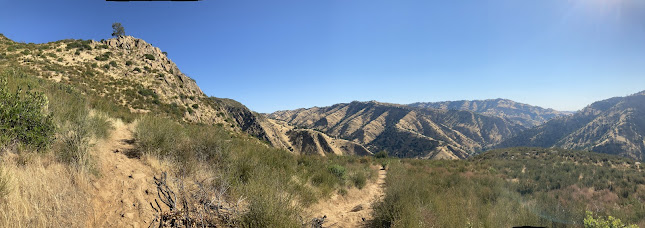
The Tuleyome trails area to the north and west of me is beautiful in the late fall and winter. In the spring, however, it just explodes with intense beauty. Everything is green from winter rains. A sequence of different populations of spectacular wildflowers cycles through the area from February to June. The peak is usually late April when there is plenty of moisture left over from the winter, plenty of sun, and enough warmth to make hiking really ideal. The Northern Inner Coast Range of California, where the Berryessa Snow Mountain National Monument exists, is indescribably beautiful at that time. As we approach mid summer, however, it starts to get brutal. The chaparral plants are still green, but drying fast. The seasonal creeks stop flowing. The blooming wildflowers are rotating into species that are not as showy. There are still some there, but you have to look harder to appreciate them. The invasive annual grasses die and turn completely brown and dry, just begging to ignite. The thistles and poison oak are happier than ever. And it is hot… and dry. There is a real chance of getting caught in a serious wildfire if you are out hiking on a hot windy day that is all too frequent in recent years. Most of the area has burned at least once in the last 20 years. If you smell any smoke, you get out as fast as you can. It generally still cools down at night, so you can still enjoy some great hiking if you go out in the early morning, but hiking around here in the summer is a completely different undertaking than it is during the rest of the year. If someone is only exposed to this area in the worst of the summer, they could almost be forgiven for wondering why anyone cares about this area at all. It’s temporal variability and diversity, however, are a huge part of it’s value. Each week of the year shows a different biologic facial expression, but the underlying bones of the land, the geology, stays the same.
The Tuleyome trails area to the north and west of me is beautiful in the late fall and winter. In the spring, however, it just explodes with intense beauty. Everything is green from winter rains. A sequence of different populations of spectacular wildflowers cycles through the area from February to June. The peak is usually late April when there is plenty of moisture left over from the winter, plenty of sun, and enough warmth to make hiking really ideal. The Northern Inner Coast Range of California, where the Berryessa Snow Mountain National Monument exists, is indescribably beautiful at that time. As we approach mid summer, however, it starts to get brutal. The chaparral plants are still green, but drying fast. The seasonal creeks stop flowing. The blooming wildflowers are rotating into species that are not as showy. There are still some there, but you have to look harder to appreciate them. The invasive annual grasses die and turn completely brown and dry, just begging to ignite. The thistles and poison oak are happier than ever. And it is hot… and dry. There is a real chance of getting caught in a serious wildfire if you are out hiking on a hot windy day that is all too frequent in recent years. Most of the area has burned at least once in the last 20 years. If you smell any smoke, you get out as fast as you can. It generally still cools down at night, so you can still enjoy some great hiking if you go out in the early morning, but hiking around here in the summer is a completely different undertaking than it is during the rest of the year. If someone is only exposed to this area in the worst of the summer, they could almost be forgiven for wondering why anyone cares about this area at all. It’s temporal variability and diversity, however, are a huge part of it’s value. Each week of the year shows a different biologic facial expression, but the underlying bones of the land, the geology, stays the same.
Did I mention poison oak? I got a touch of it on the Cold Canyon hike, July 7. It's not too bad yet, but sometimes it takes a few days to develop. I may have to include a picture if it becomes photogenic.
Stebbins Cold Canyon trailhead signs
The ridge at Stebbins Cold Canyon overlooking Lake Berryessa, July 7, 2024

Looking down from Peña Adobe hill, July 9, 2024
Peña Adobe, Vacaville, CA
View from Peña Adobe. Mt. Diablo is in the distance.


Comments
Post a Comment